
Draw me a city
Sociologists, economists, geographers, and public officials have different approaches to cities. The concept of a city is multidimensional, and there are several ways to define it. In France, INSEE provides several zoning systems, all based on groupings of municipalities: the degree of urbanisation classification, functional areas, and urban units. These territorial classifications are powerful tools for analysing urban phenomena, even if they provide a stylized interpretation of reality. They are complementary and offer different views of today’s cities, with varying levels of relevance depending on what one wishes to analyse. INSEE now favours the degree of urbanisation and functional areas to describe France’s urban structure.
The concept of a city is multidimensional. It encompasses different functions, including political-administrative, economic, and cultural. These functions have evolved as cities have developed, first as ancient cities in Antiquity, then as walled cities in the Middle Ages, then as pre-industrial cities, and finally as post-industrial cities today.
The geographical and demographic expansion of cities, or urbanization, is a massive phenomenon worldwide. In France, it was very rapid in the post-war period and has continued at varying rates since then (Baccaïni and Sémécurbe, 2009; Beck et al., 2023). This urbanization has been accompanied by the development of metropolisation, i.e., the concentration of populations and economic activities in large cities, reflecting their adaptation to the globalized economy. This has led geographers to propose a system of cities that describes the urban structure of countries and how they are connected.
Diverse approaches to the city, by sociologists, economists, geographers, and public actors
The multi-dimensionality of the city makes it a difficult concept to approach in its entirety. Different fields of research therefore aim to describe it according to their own paradigms.
Sociologists take an approach to the city that focuses on its human dimension—a city is a concentration of people in a limited space—without reducing it to the mere quantitative measure of its inhabitants, because interactions between inhabitants create a sense of belonging to a community. However, the sociological description of the urban environment tends to highlight the heterogeneity of the environment, the feeling of anonymity, etc. “The city is at once a territory and a population, a material setting and a unit of collective life, a configuration of physical objects and a hub of relationships between social subjects” (Y. Grafmeyer, 1994). There is no perfectly objective definition of the city (Marchal and Stébé, 2024).
In terms of geographical economics, research experienced a revival in the 1990s under the impetus of Krugman (1991), and developed in particular to analyse the mechanisms behind the agglomeration of activities (Combes et al., 2012). For proponents of these new geographical economics, cities do not have precisely defined boundaries. The continuous space in which interacting agents operate is, in principle, infinite; urban space is where the rent offered (wealth generated by the activities located there) is higher than the agricultural rent (Gilli, 2001).
A city is also a geographical reality; it is described by geographers as the concentration of people and activities in a specific, well-defined location. But the city is not a closed entity, restricted to the administrative boundaries of the municipality. Geographers seek to describe the relationships between the urban centre and its surrounding area, as each city has a zone of influence that varies in size. It is part of a system of relationships with the surrounding rural areas, with more distant areas, and with other cities, whether economically, for example for its supply needs, or administratively, for example in its relations with the regional capital. The description of the city is therefore less physical than functional. Political-administrative, economic, and cultural functions are the main urban functions; they are not necessarily fulfilled by the same city in a given territory.
The city is also an area of intervention for local public officials. Thus, several categories of public intercommunal cooperation establishment (EPCI, Etablissement public de cooperation intercommunale) have an urban dimension, in particular metropolitan areas, urban communities, and conurbation communities.
Finally, defining a city is a necessity at the international level. Recognizing that cities face many challenges around the world, the United Nations (UN) has provided two definitions to support the sustainable development goal of “making cities and human settlements inclusive, safe, resilient, and sustainable”:
• the city as defined by its urban extent, measured using satellite image analysis techniques to extract information on the morphology of human settlements and the density of built structures;
• the city as defined by its degree of urbanisation; a method used by the European Commission. Densely and moderately populated areas together form the city’s boundary
In France, these two definitions have been used successively by INSEE.
Historically, since the early 1960s, the urban dimension of municipalities was defined by their inclusion in an urban unit, a zoning based on the continuity of built-up areas. Since 2020, the urban dimension of municipalities has been defined on the basis of population density, using the degree of urbanisation and, in a more extensive view, on the basis of the functional areas zoning. These three zoning systems are described in more detail below.
The city defined by the continuity of the built environment
During the 1954 census, INSEE carried out an initial delimitation of cities and urban areas by observing the continuity of built-up areas. From then until 2020, it defined the concept of urban areas as urban units, i.e., a municipality or group of municipalities with a continuous built-up area (no gap of more than 200 meters between two buildings) with at least 2,000 inhabitants. Urban units can extend across several départements (NUTS3 level) or even across national borders. Municipalities outside urban units were then considered rural municipalities.
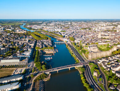
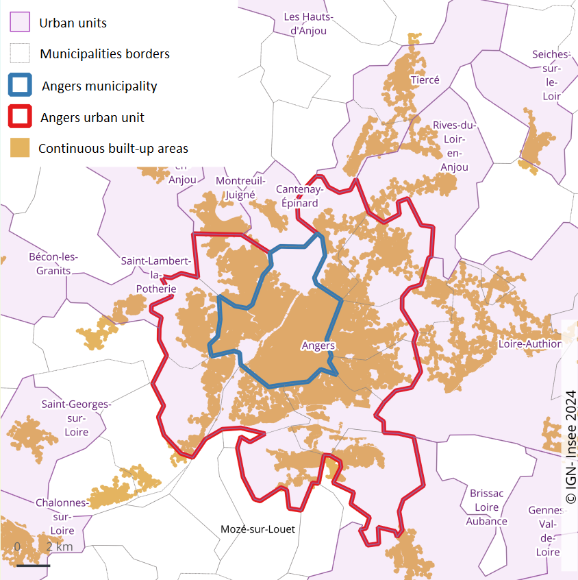
In the example of Angers (Figure 1), the city extends beyond the administrative border, with buildings spilling over outside the municipality limits. The urban unit of Angers thus extends over 12 municipalities, including Angers, which are linked by a continuous urban built environment. It covers 248,000 inhabitants, including 157,000 in the municipality of Angers. It borders other urban areas, defined around other built-up areas, such as Saint-Lambert-la-Potherie (to the west), but also municipalities that do not meet the thresholds required to constitute an urban area, such as Mozé-sur-Louet (to the south)
Figure 1 – Angers, the central city of an urban area with a population of 248,000
Urban units are now less relevant for understanding these phenomena. They remain suitable for studies relating to urbanisation and urban sprawl over long periods, and especially for those focusing on urban policy, with urban units serving as a legal reference for defining the boundaries of priority neighbourhoods (priority geography of urban policy carried out by the government and local authorities).
The city as opposed to rural areas
Since 2020, the rural or urban dimension of municipalities has been defined on the basis of population density criteria. This definition is supported by the National Council for Statistical Information and the Association of Rural Mayors of France (CNIS, 2020). It is based on the degree of urbanisation classification, which is derived from an international methodology. The urban/rural distinction is therefore no longer made “by default” based on the continuity of built-up areas.
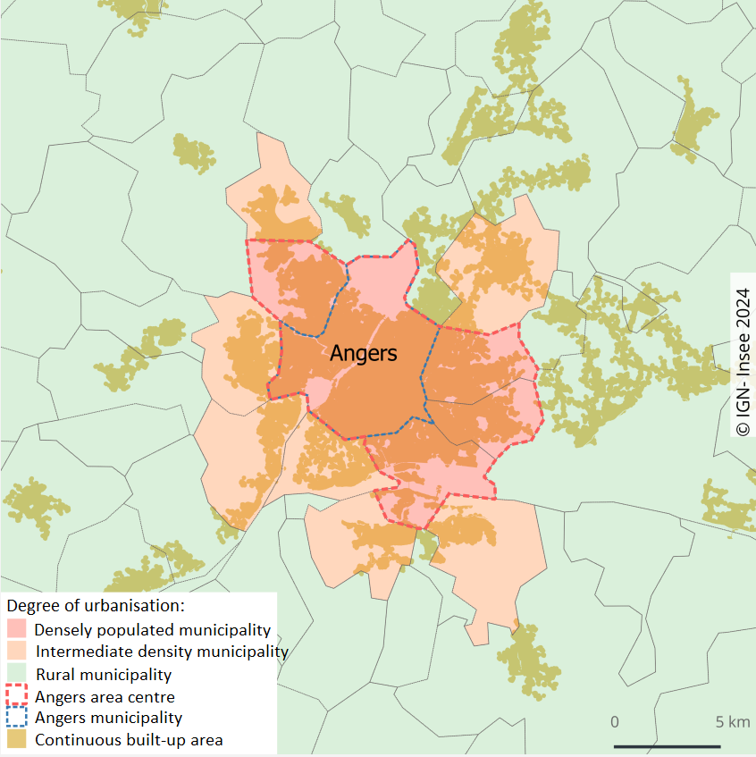
The degree of urbanisation allows municipalities to be classified according to the distribution of the population across their territory. It is based on population density data for 1 km² squares and on the proportion of the population of each municipality residing in these more or less dense squares.
At a more aggregated level, the degree of urbanisation defines densely populated areas, intermediate density areas, and rural areas. The seven-level classification refines the last two levels by segmenting each into three, from dense towns to mostly unhabitated areas.
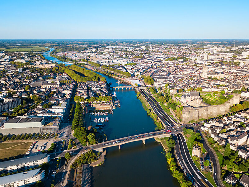
Four municipalities adjacent to Angers have the same density level and, together with the municipality of Angers, form a dense urban area with 210,000 inhabitants, which is slightly less than the urban unit (Figure 2).
In France, in 2021, urban municipalities (dense and intermediate levels combined), as defined by the degree of urbanisation, are home to 67% of the population.
Figure 2 – Angers and four adjacent municipalities, a densely populated centre with a population of 210,000
The city in its environment
The city, as a geographical object, is not just a closed entity, as we have seen, restricted to the administrative boundaries of the municipality. It is also connected to its environment, urban or otherwise, through the influence it exerts on it.
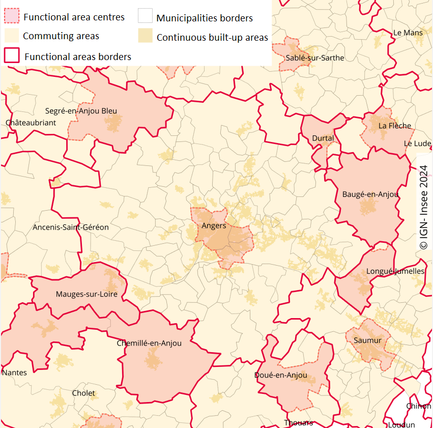
The functional areas zoning thus convey a more extensive vision of urban life, based on interactions between peripheral municipalities and population and employment centres. In the case of Angers, the five municipalities of the 210,000-inhabitant hub are joined by a commuting area of 76 municipalities with a total population of 231,000 (Figures 3 and 4).
A city’s functional area is a contiguous group of municipalities, consisting of a population and employment centre and the surrounding municipalities in which at least 15% of the working population is employed in the centre. The most populated municipality in the centre is called the central municipality, while the other municipalities in the centre are traditionally referred to as the commuting area.
The 699 functional areas vary greatly in size, ranging from 13.1 million inhabitants for Paris to less than 2,000 inhabitants for the functional areas of Villers-la-Montagne (Meurthe-et-Moselle), Val-d’Isère (Savoie), Flamanville (Manche) and Montreuil-sur-Mer (Pas-de-Calais).
Figure 3 – Angers, the central city of the Angers functional area, whose commuting area has a population of 231,000
Functional areas provide an insight into ‘diffuse’ urbanisation: in 2021, a total of 34.3 million inhabitants in France live in a city centre, representing 51% of the population, with 43% living in the surrounding municipalities and 6% outside an functional area.
At European level, ‘functional urban areas’ are limited to the ones of densely populated municipalities, known as cities (Eurostat, 2017). In France, 38% of the population lives in a city, which is less than in the Netherlands and Spain, where more than half of the population does so. Some French municipalities are part of the functional areas of cities located abroad (Basel, Charleroi, Geneva, Lausanne, Luxembourg, Monaco and Saarbrücken).
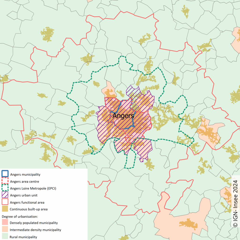
Figure 4 – Different city boundaries – The case of Angers
INSEE now favours the degree of urbanisation and functional areas to define the concept of a city
By combining them, the two zoning systems – degree of urbanisation and functional areas – make it possible to understand dense urban areas (degree of urbanisation) and dispersed urban areas (functional areas), particularly the outskirts of conurbations that are largely dependent on them, and thus to describe the urban structure of France. These outskirts include rural municipalities, classified as periurban in areas with more than 50,000 inhabitants. These zoning systems are therefore suitable for analysing economic and social phenomena, particularly for comparisons between territories at the regional, national or European Union level.
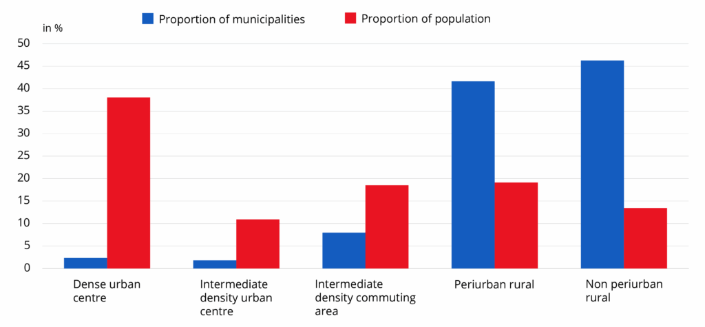
Urban centres, consisting of densely populated or intermediate density urban centres, represent only a small proportion of municipalities (less than 5%) but account for nearly half of the population. In the periphery, urban municipalities and periurban rural municipalities each account for 19% of the population (Figure 5). Non periurban rural areas, located outside a functional area with at least 50 000 inhabitants, account for 13% of the population.
Figure 5 – Distribution of municipalities and population in 2021 according to type of area
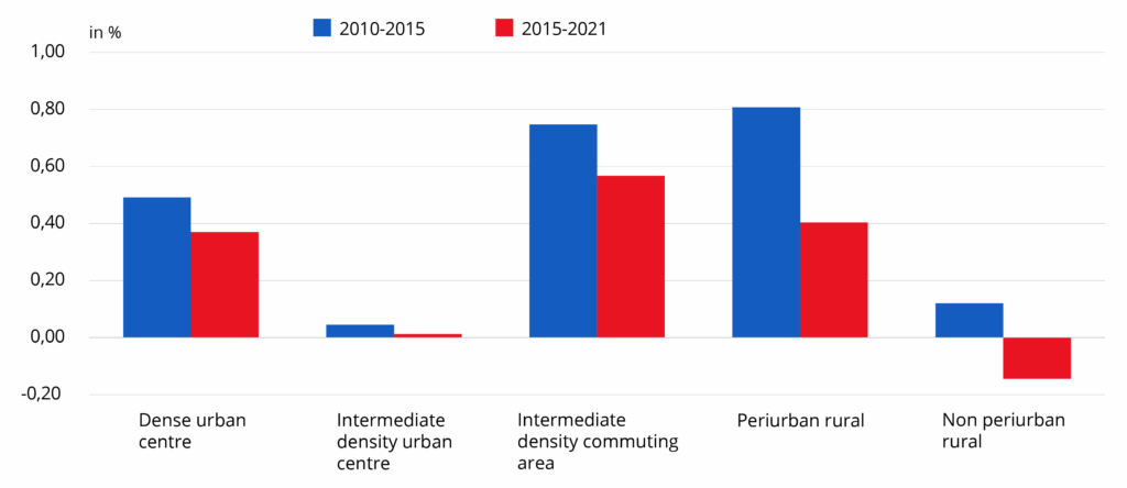
Over the 2015-2021 period, the population grew in dense urban areas as well as in urban commuting areas and rural periurban areas (Figure 6). This continues the trend seen in the previous period, albeit at a slower pace. Over the decade as a whole, population growth was strongest in municipalities in commuting areas, whether urban or rural periurban: around 7%, compared with 3.5% for urban centres (growth mainly due to dense urban centres) and less than 1% for non periurban rural municipalities.
Figure 6 – Population change between 2010 and 2021 by type of space
These zoning systems outline different parts of the city. They are accessible to everyone for analysing urban questions in all their dimensions. It’s up to you to make use of them:
Is my municipality considered urban according to INSEE? Find the answer here.
Which city’s functional area does my municipality belong to? Find the answer here.
References
- Marchal H., Stébé J-M., 2024, « La sociologie urbaine », Que Sais-je ? Édition 2024
- Beck S., Pégaz-Blanc O., Khamallah A., 2023, « La rétropolation en 2010 du zonage en aires d’attraction des villes de 2020 », Document de travail Insee n° 2023-11, mai
- Beck S., De Bellefon M.P., Forest J., Gerardin M., Levy D., 2023, « La grille communale de densité 7 niveaux », Documents de travail Insee n° 2022-18, janvier
- D’Alessandro C., Levy D., Regnier T., 2021, « Une nouvelle définition du rural pour mieux rendre compte des réalités des territoires et de leurs transformations », La France et ses territoires, Insee Références, édition 2021, avril
- Charton C., Couleaud N., Lenseigne F., Moreau G., 2021, « Les territoires au cœur des crises, des disparités et des enjeux de développement durable », La France et ses territoires, Insee Références, édition 2021, avril
- De Bellefon M-P., Eusebio P., Forest J., Pégaz-Blanc O., Warnod R., 2020, « En France, neuf personnes sur dix vivent dans l’aire d’attraction d’une ville », Insee Focus n° 211, octobre
- Costemalle V., 2020, « Toujours plus d’habitants dans les unités urbaines », Insee Focus n° 210, octobre
- Conseil national de l’information statistique (Cnis), 2020, Avis rendu par la commission territoires du 26 novembre 2020
- Eurostat, 2017, Manuel méthodologique des statistiques urbaines
- Combes P-P., Duranton G., Gobillon L., Puga D., Roux S., 2012, « The productivity advantages of large cities: distinguishing agglomeration from firm selection », Econometrica, Vol. 80, N°. 6, novembre
- Baccaïni B. et Sémécurbe F., 2009, « La croissance périurbaine depuis 45 ans. Extension et densification », Insee Première n° 1240, juin
- Gilli F., 2001, « Les modèles urbains en économie et géographie », L’Espace géographique, Belin
- Grafmeyer Y., 1994, « Sociologie urbaine », Nathan
Credits: ©saiko3p – stock.adobe.com